Loading...

Vindobala

August 2024

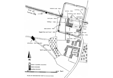
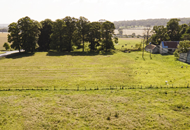
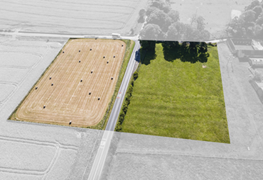
Rudchester Fort (Vindobala or Vindovala) is the fourth fort along Hadrian's Wall, after Segedunum (Wallsend), Pons Aelius (Newcastle) and Condercum (Benwell). It is at the top of a flat ridge between the March Burn to its west, an ancient route to the ford at Newburn, and the Rudchester Burn to the south and east. Its Roman name, Vindobala or Vindovala, is translated as White Peak or While Walls, although the reason for the name is unknown. The outline of the fort is clearly visible in aerial photographs as it straddles the Military Road (B6318) (from Tynedale U3A. Hadrian's Wall Group and NorthOfTheTyne.co.uk websites).

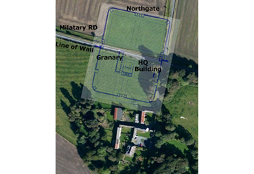
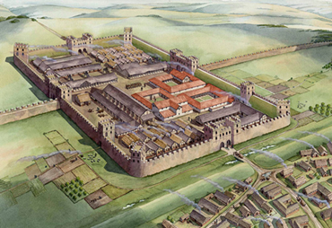
The fort measures 170m by 120m (4.5 acres) and was garrison to around 500 Cohors I Frisiavonum recruited from lower Germany in the 3rd and 4th centuries AD.

There were six gates and towers at each corner and also on either side of the main gates. The Vallum passed about 220m south of the fort, and there was a vicus to the south and south west.

Rudchester Roman Fort (Vindobala)

Click here for a high resolution photograph in a new window:

Rudchester Roman Fort (Vindobala)
Reconstruction of the fort overlayed on an aerial image

Rudchester Roman Fort

Click here for more information in a new window:

Rudchester Roman Fort
This is a wider view indicating the topography as Rudchester slopes down to the South.

Rudchester Roman Fort

Click here for more information in a new window:

Rudchester Roman Fort
An artist (Mike Ritchie) impression of the fort and vicus to the South.

The fort appears to have been very well preserved until the 1720s - Horsley visited Rudchester and noted: ‘This fort has been very considerable, as the ruins of it at present are very remarkable…’ but he did not see any remains of the vicus, which he assumed was beneath the buildings of Rudchester (Horsley, Britannia Romana or the Roman antiquities of Britain, 1732).

The first image is of a map (unknown source) indicating some 1886 "buildings" excavations, the extensive 1924 excavations, more limited excavation in 1972, and the route of the "new" mains water pipe in 1989. Also shown is the site of the Gaint's grave discovered in 1776 and Mithraeum excavated in 1884 and 1953.

The first major excavations were undertaken by Parker Brewis in 1924 and showed the fort to project north and south of the Wall. There is an excellent account of the excavations in Archaeologia Aeliana 1925, Series 4, Volume 1, Pages 93-120 which is available from the Society of Antiquaries, Newcastle upon Tyne. This is a photograph of the excavation of the west gate in 1924 courtesy of the Society of Antiquaries, Newcastle upon Tyne.

The map shows excavations of the vicus in 1851 (east of the road) and in 1953 (west of the road, under the current drive). We do have not yet found any description of these studies.

In 1972 part of the south-eastern quarter was excavated (Gillam et al. 1973). Again there is en excellent account of the work in Archaeologia Aeliana Series 5 Volume 1 Pages 81-85 which is available from the Society of Antiquaries, Newcastle upon Tyne.

An analytical field survey was carried out in 1989 Aeliana Series 5 Volume 19 Pages 25-31 available from Society of Antiquaries, Newcastle upon Tyne). Two of the main gateways were excavated, as well as a large granary and part of the headquarters with a hypocaust to the Commandant’s house.

Rudchester Excavations

Click here for a high resolution photograph in a new window:

Rudchester Excavations

South Gate and Headquarters Excavation 1925

Click here for more information in a new window:

South Gate and Headquarters Excavation 1925
This shows the 1925 excavations at the South Gate. In the background is the Malthouse - with a much smaller door than the current barn opening - and the Carthouse with its West-facing door in tact.

South West Turret excavations 1925

Click here for more information in a new window:

South West Turret excavations 1925
Extensive excavation at the site of the current Hadrian's Wall path sign.

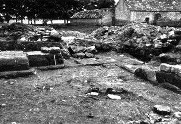
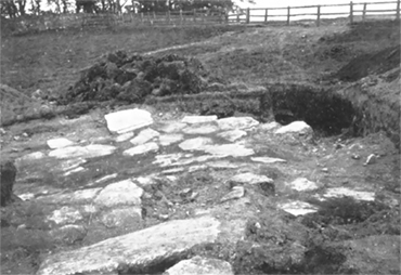
Vindobala was destroyed by fire in the late 2nd or early 3rd century. Part of the fort was re-commissioned around 370 AD with timber buildings on stone sill-walls, but by the end of the 3rd century the fort fell into disuse. Its stone was plundered to build Rudchester Manor, the surrounding farm buidings and the military road in the 1720s.

All that can be seen today is a rectangular mound circled on its South and West sides by the Roman Wall Path, with sheep grazing - little changed from the sketch by Rev Coates in 1879. The fort's field was sold by Northumberland County Council on 28th September 2012.

Further information about Rudchester fort is available from:
Heritage Gateway - Rudchester Roman Fort
Wikipedia - Vindobala
Northumberland sites and monuments record - Rudchester Roman Fort
English Heritage - Hadrian's Wall: Archaeological research 1976-2000

Rudchester 1879

Click here for a high resolution photograph in a new window:

Rev James Irwin Coates 1879
Rev Coates made a series of drawings of the Wall from 1877 to 1896 which, on his death, were given to Ackworth School in Yorkshire. This sepia colour wash drawing of Rudchester Fort from the South West Corner is dated 1879. More of these drawings are reproduced in Alan Whitworth's book - Hadrian's Wall through time.

Vindobala from the West

Click here for more information in a new window:

Vindobala from the West
This is a similar view to that drawn by Coates. The mound of the Fort has not changed although there are some minor changes in the farm buildings.

Vindobala from the air

Click here for more information in a new window:

Vindobala from the air
The only way to see the entire fort is from the air. This was also taken from the West and shows the fort divided by the Military Road which runs along the line of the Wall. The South section is slightly larger than the North.