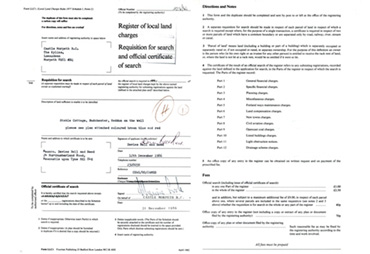
1986 Land Charges
This is a stapled series of 5 double-sided photocopied, typed, stamped and handwritten sheets detailing searches relating to Stable Cottage, dated 31 December 1986, with a receipt for a £14.40 cheque from the solicitor Davies, Bell & Reed, dated 15 December 1986.
Part 3: Planning Charges 2018/86
74/D/230B - Details of change of use from agricultural store to agricultural dwelling - 10 October 1977
82/D/390 - Alterations to provide kitchen/dining area on ground floor with additional bedroom and bathroom on first floor - 20 August 1982
These appear to refer to planning permissions for alterations to Stable Cottage after its gift from Tom James to his daughter Julia Elizabeth Miranda James on 24th December 1986.
Part 4: Miscellaneous Charges 2018/86
Improvement Grant 865
- 1st only payment: Conditions as to future occupation: 5 years from 17 February 1983
- 2nd & Final payment: Conditionas as to future occupation: 5 years from 8 December 1983
This appears to relate to grants from Castle Morpeth Burrough Council (CMBC 1974-2009) for improvements to Stable Cottage which included conditions that it should be used to house agricultural workers.
The Ancient Monuments and Archeological Areas Act 1979 Section 1(9): The inclusion therein of the monument known as Hadrian's Wall and Vallum in the wall mile 13 from Turret 12.b to Rudchester Fort County Monument 28(2). Nat. Grid Ref: 78NZ 121 683 112 674. Department of the Environment, Room 313, Fortress House, 23 Savile Row, London W1X 2HE. 2 November 1982.
Part 6: Land Compensation Charges 2018/86
Land compensation Act 1973 - Section 8(4) Ref: CNE 225/1/27/010
Department of Transport, Approximately 258 acres of arable land and pasture known as Rudchester Farm. Construction of Horsley, HEddon, Throckley and Walbottle Bypass on A69. Department of Transport North Eastern Road Construction Unit HQ, Windsor House, Cornwall Road, Harrogate, N Yorkshire, 9 September 1980.
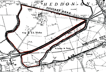
Land Map
Click here for a high resolution scan in a new window:
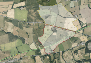
A69 Route
Click here for a high resolution photograph in a new window:
Full document
Click here for the full pdf document in a new window: